Thursday, April 30, 2015

Redesigning Our Cities and Highways to Help Feed Monarch Butterflies

Could establishing milkweed plots alongside greenways benefit wildlife and reduce maintenance costs for city greenways?


Redesigning Our Cities and Highways to Help Feed Monarch Butterflies:


For this reason, groups like the Pollinator Partnership are working to convince infrastructure owners to allow the planting of milkweed in unlikely places. They aren't asking for vast butterfly preserves, simply for strips of land otherwise forgotten. For example, the Pollinator Partnership is seeking national legislation that would encourage state highways to plant bee- and monarch-friendly habitats on highway medians instead of mowing them down.

Knoxville Mercury Article Highlights First Creek Greenway Threat Posed by Proposed Development

Print
Retaining Wall, Fuel Center, Loading Docks.  Development, or continued abuse of First Creek?


Article in the alternative weekly "The Knoxville Mercury" highlights threat to First Creek and the First Creek Greenway posed by a potential development in North Knoxville in "More Walmarts on the Way:"
In the last few years, the city spent millions to straighten a couple of deep curves in the creek to increase the flow and prevent the flooding of streets and homes. Thomas says he is also worried about how the project could affect First Creek Greenway, which he helped establish, and its planned northward expansion. 
Polestar had an informal meeting with city engineering officials last week to discuss its ideas for the site, which includes a 9-foot retaining wall above First Creek in its floodway, but no stormwater retention pond. 
Generally, a floodway is the area next to a creek that must be preserved to prevent a rise of more than a foot in the water surface level. 
But city storm-water engineer David MicGinley says building the retaining wall in the floodway won’t necessarily cause a foot rise in the water level there. On the other hand, current rules usually require a 60-foot buffer of undisturbed vegetation from the top of the creek bank or the floodway, says Chris Howley, who supervises plan review and development inspections for the city engineering department. 
The developer would be required to prevent stormwater runoff from increasing—or prove that it would actually be better for the creek if stormwater flowed out all at once, McGinley says. Even without space for a holding pond, there are other tools for reducing runoff. For example, parking lots can be built using pavers that allow water to penetrate, or underground storm-water tanks can be installed, Howley says. (Another creative option is planting a grass roof on the building.) 
McGinley points out that the majority of the site—the church portion—is already covered in buildings or pavement. “There are hurdles associated with the development, but I didn’t see any deal-killers,” Howley says.

I'm disappointed with the lack of protections that would seem to allow this development. It seems obvious to me as a trained ecologist that our laws and regulations are too permissive if nothing is a "deal-killer" in this proposal. Thermal pollution, parking lot runoff, lack of a stormwater detention pond - all of these are threats to First Creek that will only be exacerbated by this development.  But, Knoxville appears to lack local regulations that would protect First Creek - not entirely surprising, since First Creek has suffered generations of abuse.

The property the church is sited on was established in 1948; it seems obvious that whatever modifications were made to the watershed were done prior to modern protections.

The 1948 date probably explains why the property is an island "above flood zones" when the surrounding parcels are largely not.

First Creek Watershed Flood Zones from KGIS.org

Seems like zoning is the biggest hurdle, for now, although I'd prefer a requirement for new developments that mandates an easement for a greenway along the riparian buffer if this deal goes forward.  We've seen this happen at other Wal-Mart sites in Knoxville; the Walmart Supercenter at Kinzel Way in East Knoxville is an example where Love's Creek Greenway was built as part of the development.
Love's Creek Greenway at Walmart Superstore in East Knoxville

For now though there still seems like a chance to stop the development through denial of re-zoning:

"Trent says Knox Heritage plans to fight rezoning of the Howard house while raising money to buy it. She predicts the zoning question will end up in City Council’s lap, which is part of the reason for sponsoring the change.org petition—she wants to be able to convey to local politicians just how many people oppose the project."


Ijams adds zipline challenge park along Will Skelton Greenway

Note that this is adjacent to the Will Skelton Greenway.


Might this increase Greenway usage?


Can Knoxville's urban youth bike safely to Ijams to enjoy the nature center?


Not yet - James White Parkway is a safety challenge.


But, it may be possible soon.


Let's hope for continued, sustainable investment in the Greenways network.


Ijams adds zipline challenge park:


Burt said anyone ages 5 and up will be able to enjoy the ziplines anchored anywhere from 10 to 60 feet in the air. The cost will be $39 to $49 a person, depending on a person's age and amount of access to the trails.

Wednesday, April 29, 2015

Bike/Ped Facilities Plan Missed Connection

Hi Jon,

I attended the bike facilities plan meeting last year at the East Tenn. History Center.

I recommend and discussed with the consultants a connection between the Old City and the Riverwalk via Central Avenue.  I suggested a connection to the pedestrian bridge over Neyland at the City County Building, continuing on to Second Creek Greenway at Neyland Drive as a way to provide an alternative connection to UT campus that avoids the more "pedestrian centric" Volunteer Landing and avoids crossing Neyland Drive at all.  The consultant drew the route out on a printed map with a big permanent marker so there was no confusion.

I cited safety, travel time, and scenic value as rationales for this path from the Old City to UT Campus.  Among other reasons improvements are needed at this site: the pedestrian bridge over Neyland is essentially a dead-end for anyone in a wheelchair; ​there's no curb cut, and even if there was, Walnut Street isn't exactly ADA compliant.

I missed the most recent bike ped facilities plan meeting but reviewed the final report at <http://www.cityofknoxville.org/bicycleplan/feb2015_finalreport.pdf>.

The report states "...many new routes/facilities were suggested based on individual personal preference, the following represent comments that were more broadly supported..."

"Broad support" seems an unfortunate criteria, as any unique idea would inherently be dropped from the final report if one person suggested ideas no one else thought of.

Indeed, my suggestion doesn't feature in the final report.  My training in Library Sciences leads me to hope public comments are appropriately preserved and were integral to the report's final recommendations, yet, perhaps not rhetorically, I have to wonder: what's the point of an individual attending public meetings and providing input if that input is not addressed unless it has "broad support?"

Parks and Rec is also neglecting to study a potential Central Avenue connection to Neyland Drive as part of their Greenway Corridor Feasibility Study.

I'm aware Hall of Fame, Willow Avenue, Jackson Avenue, Morningside Park and James White Greenway are all being studied as connections from East and North Knoxville to the Tennessee River and the UT Campus.

While any bike/ped facility is welcome over none, each of these options have inherent limitations impacting safety, speed, and general recreational enjoyment as routes to Volunteer Landing, Downtown, and the University of Tennessee. Given these limitations, an alternative route that increases safety, travel time, and scenic value is clearly needed.  I believe qualitative data sourced from interviews with bike/ped facilities users would support my opinion on this.

Therefore, I would like to propose for consideration a "William Blount Greenway" concept connecting the "dead end" pedestrian bridge at the City-County Building to the Downtown Dog Park, thereby linking the Old City to Volunteer Landing and the rest of the greenway network.

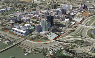
3D Rendering of W. Blount Greenway Concept, Red Line Marks Route from Dog Park to City County Bldg.

The name "William Blount" refers of course the Blount Mansion, which owns a parcel of property that would need to be traversed.  The benefit to William Blount Association seems likely to be increased recognition, visibility, and access created by the proposed greenway.  The greenway would also honor our community's heritage and help communicate the story of Knoxville's pioneer history, a key to heritage tourism and economic development.

Parcel owned by William Blount Association.  Potential for partnership?

I've put together a few sketches in Google Earth and Google Maps I'd like to share with you to illustrate the concept.

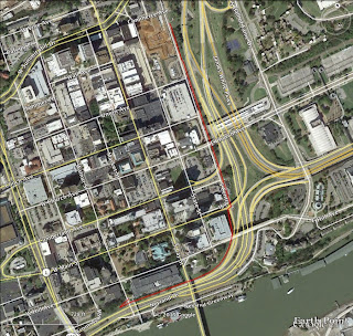
Google Earth Satellite Image Overlay with Red Line Indicating Route.  Crosses Central Avenue at Cumberland.

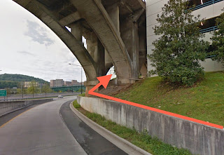
Position of bridge would require Greenway to "Thread" the bridge to pass onto W. Blount Assoc. Property.

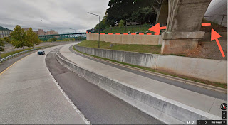
William Blount Assoc. would be a Key Partner.  Benefits might include increasing recognition, access, and heritage tourism.

I'd appreciate it if you could consider how this idea might be incorporated into the City of Knoxville's alternative transportation plans including bike/ped facilities and greenway planning.

Thanks,

Tanner

Friday, April 24, 2015

Take Virtual Hikes on Local Trails with Google Trekker

City of Knoxville Press Release:

April 22, 2015
Knoxville - Looking for a new route to jog, stroll or ride your bicycle in Knoxville or Knox County? You can now take 360-degree virtual tours of 137 miles of local greenways, park trails and multi-use paths, thanks to Google Trekker Street View imagery.

Last fall, a team of partners led by the Knoxville-Knox County Metropolitan Planning Commission used a Google Trekker backpack camera to photograph trails and attractions throughout Knox County. The available interactive imagery includes many City and County parks, bicycle trails in the Urban Wilderness Corridor, the Knoxville Zoo and the inside of Neyland Stadium on the University of Tennessee campus.

Like other Street View imagery, the photos collected through the Trekker program can be viewed on Google Maps (maps.google.com) or the Google Maps app. Some links to local destinations are also highlighted on the Visit Knoxville website, at www.visitknoxville.com/trekker.

"Not only do the Google Trekker images provide an opportunity to showcase this area's outdoor beauty," said Knox County Mayor Tim Burchett, "they also make it easier for local residents to discover - or rediscover - the outstanding recreational options available to them right here in Knox County."

Knoxville Mayor Madeline Rogero said, "This is also a great way to reach out to visitors and show off some of our beautiful natural attractions. Now people can really see what we mean when we talk about the Urban Wilderness Corridor and our miles of local hiking and biking opportunities."

Visit Knoxville President Kim Bumpas adds, "This really is an exciting tourism initiative that features Knoxville experiences in real time for our community and visitors. We will all benefit from the Trekker and learn more about Knoxville's vast array of experiences."

Twenty-six people carried the 43-pound Google Trekker camera between mid-September and late November of last year, covering 75 different locations across Knox County.

"From Neyland Stadium to Ijams Nature Center, Knoxville is full of incredible destinations. Now, these places are available for everyone around the world to see, and be inspired to visit in person," said Deanna Yick, Google Maps Street View Program Manager. "Loaning our Trekker equipment to the Knoxville-Knox County Metropolitan Planning Commission was the best way create a virtual experience of such a beautiful place."

Bees On a Greenway

Interesting story about what to do if you see a bee swarm while you're out on a Greenway.


From the photo, this looks like Cherokee Boulevard Greenway.


BEES | Amy K. Gibson, Ph.D. | LinkedIn:


On my morning run, my friend and I encountered a swarm of bees on the ground by a tree. We called the Knox County Beekeepers Association and within an hour they came to the rescue. If you see a swarm, give these folks a call and save the bees!

Thursday, April 16, 2015

URBAN WILDERNESS MOBILE MAP

This is an email from (OUTDOOR KNOXVILLE) sent by Tanner Jessel (mountainsol@gmail.com). You may also find the following link interesting: http://www.outdoorknoxville.com/urban-wilderness-mobile-trail-map

Mapped: How hard it is to get across U.S. cities using only bike lanes - The Washington Post


Mapped: How hard it is to get across U.S. cities using only bike lanes - The Washington Post:


That map has more connections, but the larger pattern remains: This network is disjointed and incomplete. We'd never build a street grid that looks like this and expect drivers to navigate the city through it. But this is the reality for cyclists, and it may help explain to other people why cyclists have such a hard time staying out of the way — off the shoulder, off the sidewalk, out of traffic or car lanes. It's quite literally not possible to travel between many points in the city using only cycling infrastructure.

Wednesday, April 15, 2015

Trail Work at Concord Park on the Roundabout property


This Saturday, the Appalachian Mountain Bike Club will be working on trails at Concord Park on the Roundabout property. Start work at 9:00. Lunch provided by Cedar Bluff Cycles and beverages by AMBC. There is about .2 mi of trail flagged and ready to be cut. Map shows where they'll be working and where volunteers should park.
Outdoor Knoxville's photo.

Wednesday, April 1, 2015

Cahaba River Natural re-vegetation in the rip rap areas along River Trace Road

Facebook: Thank you for being a friend!


Cahaba River National Wildlife Refuge added 9 new photos.
The refuge is partnering with The Nature Conservancy in Alabama, Cahaba River Society, and Birmingham Botanical Gardens to aid natural re-vegetation in the rip rap areas along River Trace Road. Yesterday Paul Freeman (TNC), Randy Haddock (CRS) and Henry Hughes (BBG) and volunteer Jack Freeman helped refuge manager Sarah Clardy plant 350 black willow stakes, pawpaw & red maples seedlings and broadcast 2,000 sycamore seeds in a 150' long area to determine which species will be most successful and develop planting protocol. We will monitor the progress of these plantings through summer and hope to do a larger effort in the fall.

We also noticed quite a bit of natural re-vegetation already happening. Some of the species we identified were ash or box elder, sycamore and pine.


https://www.facebook.com/CahabaRiverNWR/posts/838369456231407