Knox Blount Greenway Phase I Project
This project will include the construction of approximately 9,500 linear feet of asphalt greenway along the Tennessee River, a gabion wall and two pedestrian bridges.
View Current Construction Status of Knox Blount Greenway Phase I Project [PDF]
Wednesday, March 25, 2015
Knox Blount Greenway Phase I Project
City of Knoxville - Department of Engineering Capital Improvements Projects:

Fall 2014 South Waterfront News: Construction to start Sept. 22 on Suttree Landing’s Waterfront Drive
http://cityofknoxville.org/southwaterfront/newsletter/2014_fall.pdf
The contractor, Charles Blalock and Sons, Inc. has received the
Notice to Proceed (NTP), with construction to begin Sept. 22nd.
Waterfront Drive will be a new 2-lane roadway (approximately
2,988 ft) that lies north of Langford Avenue between Barber
Street and Foggy Bottom Street. Construction will consists of
asphalt pavement, concrete sidewalk, concrete curb, underground
utility installation and drainage work. Other amenities
include landscaping, rip-rap, tree plantings, decorative street
lighting and site furnishings. The contractor will begin with the
installation of sanitary sewer. Most construction work performed
should have minimal impact to residents and local traffic.
The awarded contract amount is $3,246,294.
FALL 2013 South Waterfront Newsletter: Cityview Riverwalk Extension Completed
http://www.cityofknoxville.org/southwaterfront/newsletter/2013_fall.pdf
Ronald Franks Construction LLC has completed
construction of the Cityview Riverwalk
extension. The project completion
date was Sept. 30th. A final walk-through
was performed by TDOT and City Engineering
on Sept. 26th. As a result of the
meeting, the contractor has been provided
a list of items that are to be addressed,
and a timeline. An additional meeting may
be required in the spring to evaluate the
landscaping.
The new extension lengthens the existing
riverwalk with 300 feet of concrete riverwalk
with site furnishings (benches, trash
receptacle and lighting). A 325-foot asphalt
greenway connects the riverwalk to
Blount Avenue. Together, there is over a
quarter-mile of riverwalk and greenway
connection for pedestrians and bicyclists
to enjoy.
Abbey Fields CSA Proprietor Envisions Greenway Connection
Hi Lori,
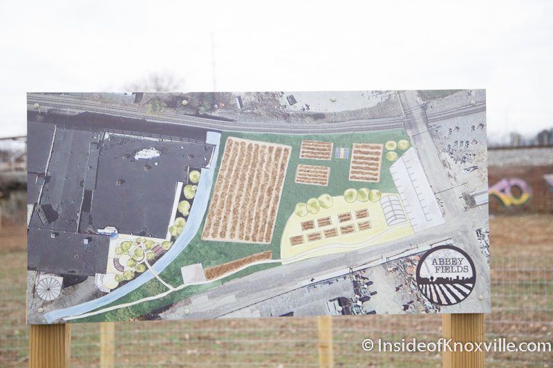
The Abbey Fields urban farmer Brenna Wright appears highly interested in having a greenway.
Brenna's latest sketch depicting the "future" of the farm seems to suggest a greenway path along the portion of her business bordering Mitchell Street.
If the city were to support the business venture's vision for a walking path parallel to Mitchell Street from Washington Ave. to Woodbine, it seems to me there'd be no need to commit city funds to replacing the sidewalk (basically non-existent at this point, due to deterioration and abuse over many years).
While this connection is not my ideal path for a "greenway," it seems like low-hanging fruit for public-private partnership. It would also minimize the overall amount of concrete hardscaping if a treelawn is placed between the greenway path and the Mitchell street curb, as the attached drawing shows.
There is already a sidewalk without a treelawn on the South side of Mitchell street. While any walking path is preferable to the existing, badly deteriorated concrete sidewalks, a sidewalk repair project on the North side would increase stormwater runoff and thermal pollution of First Creek.
Therefore, I favor a walking path separated from the road by a treelawn similar to what was done at Sutherland Avenue near West High School. A bonus would be if the path were constructed of a permeable surface.
Can you advise if there anything I can do personally to help facilitate this partnership between the city and a private landowner?
From your perspective, do you feel there is anything the Greenways Commission can do as a citizen's advisory board to facilitate this connection, which is consistently ranked as a top priority by both greenway users and official planning organizations?

The original image is found at http://insideofknoxville.com/wp-content/uploads/2015/03/Abbey-Fields-Knoxville-March-2015-1.jpg on the article "Abbey Fields: Bringing the Farm to the City."
Thanks,
Tanner
Appalachian Mountain Bike Club, Sharp's Ridge Neighborhood Connections
Sharp's Ridge is a natural area north of Knoxville, Tennessee's densely populated downtown waterfront and University of Tennessee campus.

Some refer to it as "Urban Wilderness North" as a the northern "bookend" to Urban Wilderness South just across the Tennessee River in South Knoxville.
As an oasis largely free of development, the ridge is an important bird area despite the gauntlet of guy-wires supporting massive communications towers. From hikes with my dog along the existing trails, I will offer my estimate as an amateur ecologist that the forested hillsides are also an important refuge for other species of ground-dwelling plants and wildlife, so I'm not entirely enthusiastic about developing 5.36 miles of trails, especially since trails are sometimes described as "clear cuts through the forest."
An interesting study would be to survey current invasive species prevalence, versus what becomes established following massive soil disturbance (complete with bobcat dozers)

It's also not clear from the photos that there are deterrents to sediment pollution that inevitably arises from this network of trails.
Here's a map which I feel confident in reproducing here (in so far as facts aren't copyrightable).

Grant Programs Concerning Water / Habitat
- NRCS Environmental Quality Incentives Program
- NRCS Farmland Protection Program
- NRCS Wetlands Reserve Program
- NRCS Wildlife Habitat Incentives Program
- NRCS Agricultural Management Assistance
- NRCS Conservation Security Program
- NRCS Conservation Innovation Grants
- CSREES National Integrated Water Quality Program Grants
- CSREES Water and Watershed Program Grants
- USFWS Partners for Wildlife
- USFWS Coastal Program
- FSA Conservation Reserve Program
- FSA Emergency Conservation Program
- FSA Grassland Reserve Program
- USFS Chesapeake Watershed Forestry
- RD FFB Guaranteed Loan Program (Electric Program)
- RD Water and Waste Disposal Loan and Grant Program
- EPA State Pollution Control Grants-Clean Water Act Section 106
- EPA Nonpoint Source Management Program Grants- Clean Water Act Section 319
- EPA Chesapeake Bay Program - Clean Water Act Section 117
- EPA Targeted Watershed Grants
- USACE Section 510 - Water Resources Development Act of 1996
http://www.nrcs.usda.gov/Internet/FSE_DOCUMENTS/nrcsdev11_023942.pdf
Thursday, March 19, 2015
Greenway expansion to link West Knoxville, Oak Ridge - from WBIR
The Knoxville Regional Transportation Planning Organization (TPO) aims to link West Knoxville and Knox County to Oak Ridge.
An additional 13.2 miles will join the more than 100 miles of paved greenway trails that already exist throughout the region.
It's a project that comes with an estimated price tag of $8.8 million.
The project will link three existing greenways: the Ten Mile Creek Greenway in West Knoxville and West Knox County, the Pellissippi Greenway in West Knox County and the Melton Lake Greenway in Oak Ridge.
Check out this story on WBIR.com: http://on.wbir.com/1MLXFAd
Subscribe to:
Posts (Atom)